Research Interests
Remote sensing, land cover and land use change, land change simulation, deforestation, biodiversity, urbanization, impervious surface, machine learning, urban heat island, land surface temperature
Research Experiences
Projects during PhD stage
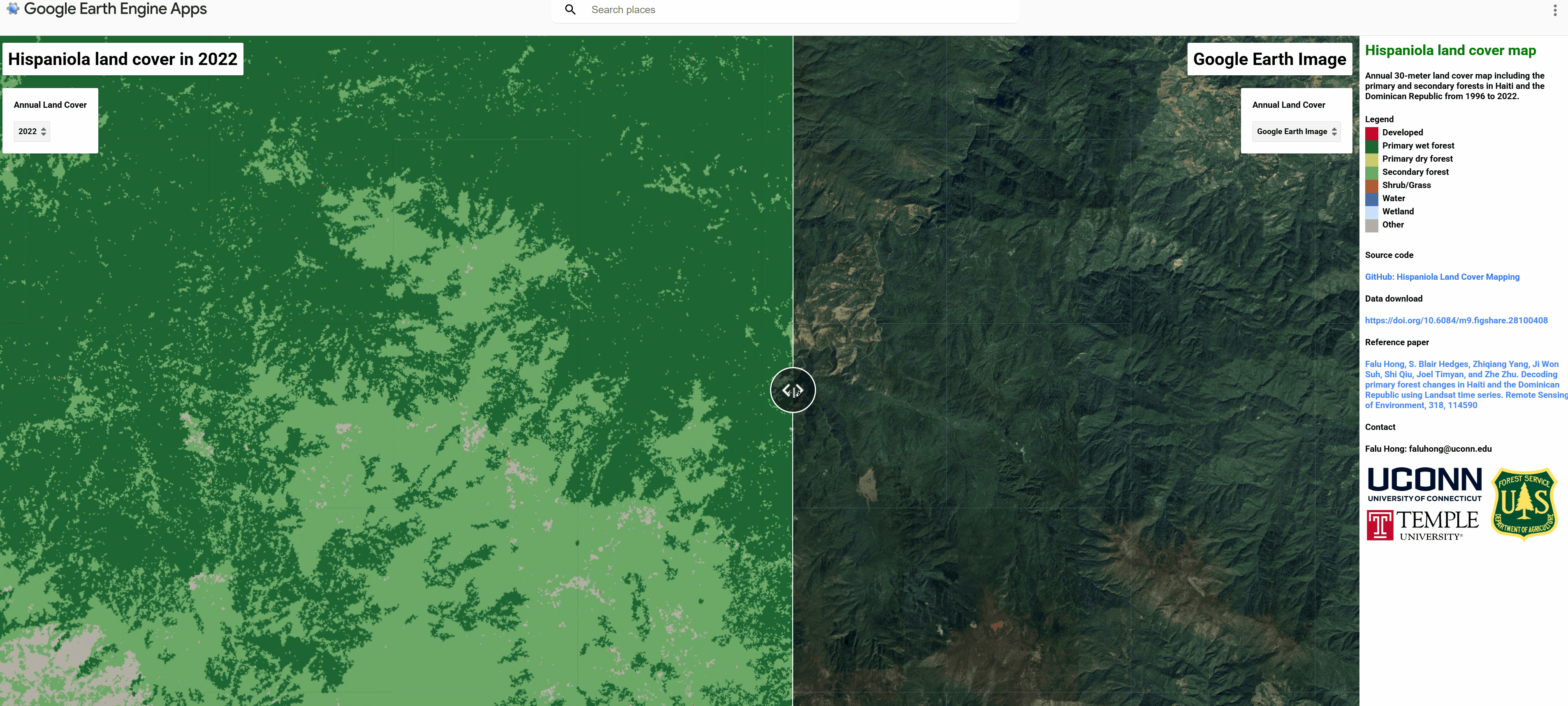
[1] Decoding primary forest (PF) change in Haiti and the Dominican Republic
- Use all available Landsat data and COLD (COtinous monitoring of Land Disturbance) algorithm to map PF change in Haiti and the Dominican Republic.
- Comprehensively compare the PF status between Haiti and the Dominican Republic, including PF change inside and outside protected areas, PF topography characteristics and fragmentation level.
- Identify the primary PF loss drivers and quantify the PF loss area caused by fire, tree-cutting, hurricanes, and landslides.
- Related Publication, Code, and Dataset.
- The generated map can be view interactively in Google Earth Engine (Hispaniola Land Cover).
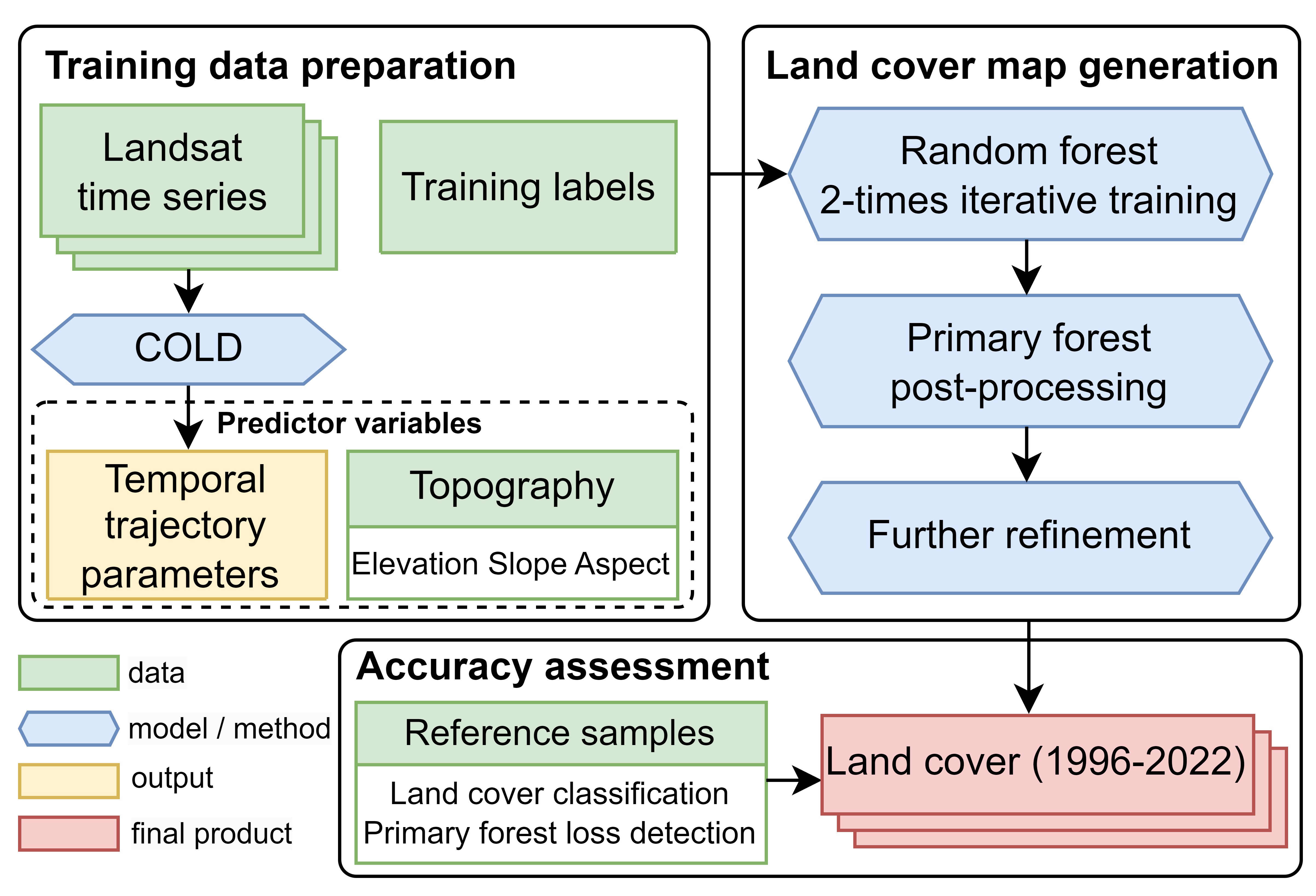
Flowchart of mapping primary forest in Haiti and the Dominican Republic
[2] Estimate the biodiversity extinction risk using land change simulation
- Simulate the historical and future land change in Haiti and the Dominican Republic.
- Link the primary forest change with the area of habitat change for amphibian species.
- Quantify the biodiversity extinction risk and protected area effectiveness.
[3] CONUS-wide subpixel impervious surface percentage (ISP) dynamics: Mapping and spatiotemporal trends
- Employ massive very-high-resolution land cover data to create the ISP map for training.
- Train the deep learning model with the ISP map and Continuous Change Detection outputs.
- Generate the 30-meter resolution subpixel-level ISP dataset for the conterminous United States (CONUS).
- Analyze the spatiotemporal changes of CONUS impervious surface during the past four decades.
Projects during Master
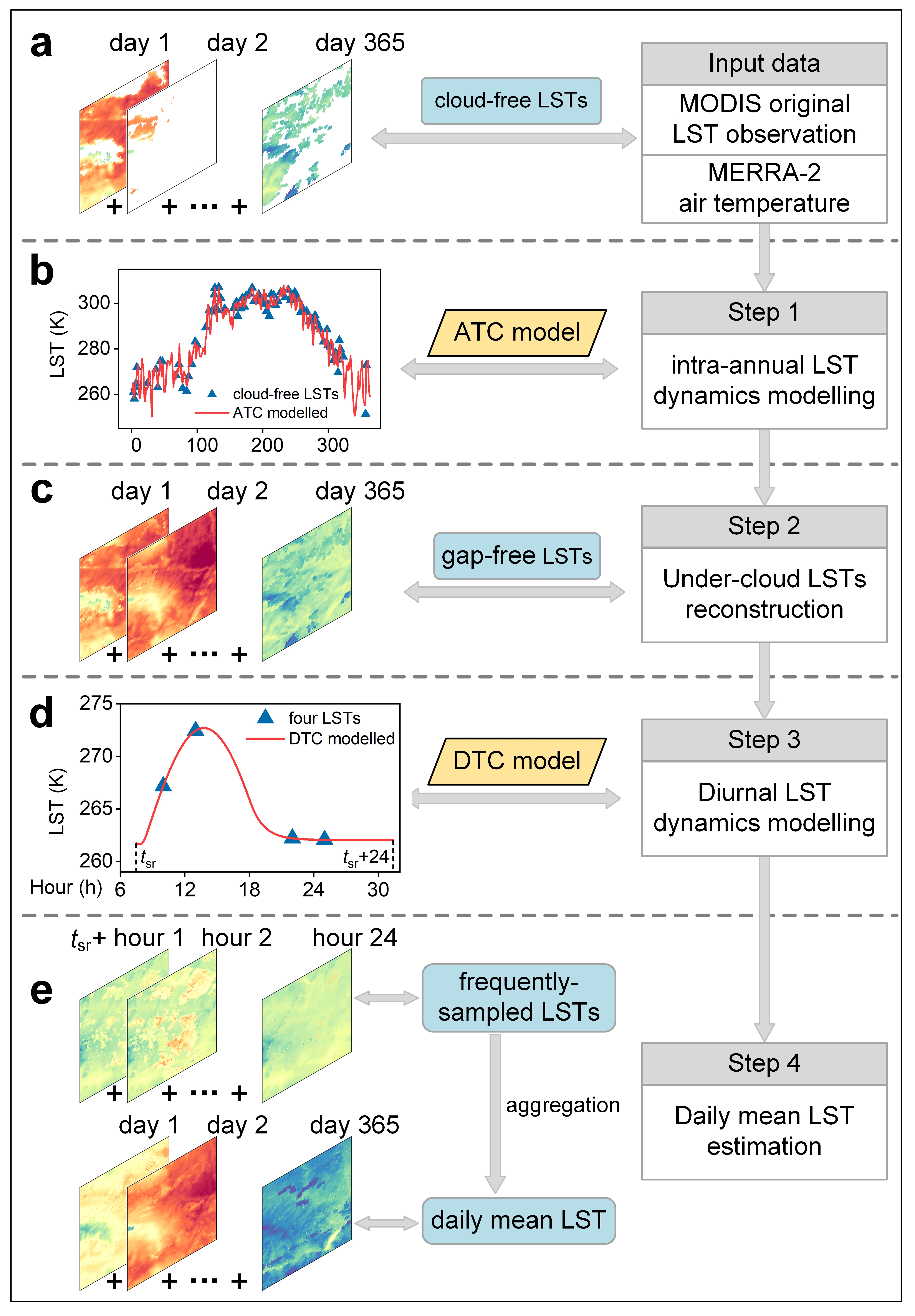
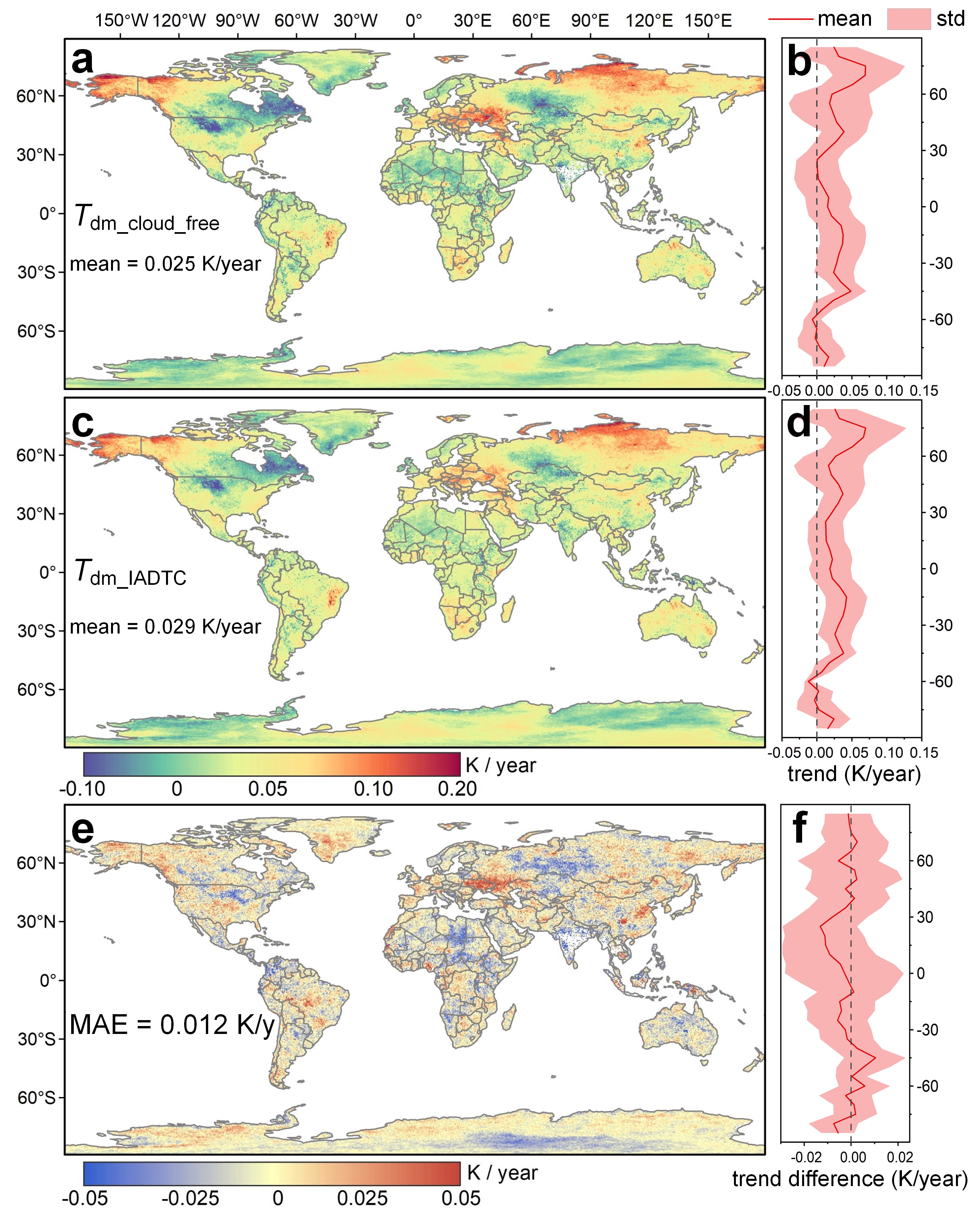
[4] Generation of global seamless daily mean land surface temperature (LST) dataset
- Enhancement of annual temperature cycle model by combining reanalysis data.
- Design a framework (IADTC framework) to generate physically true daily mean land surface temperature by combining the diurnal and annual temperature cycle models.
- Generate global daily mean LST from 2003 to 2019 and characterize the global LST trend.
- Validate the generated products with widely-distributed in-situ measurements.
- The code of the IADTC framework is available at: IADTC GitHub. The generated dataset is freely available at Zenodo.
- Related publication: Framework: Hong et al., 2021; Dataset: Hong et a., 2022.
Flowchart of the IADTC framework
Global LST trend from 2003 to 2019 using the cloud-free MODIS LST and generated seamless IADTC LST dataset
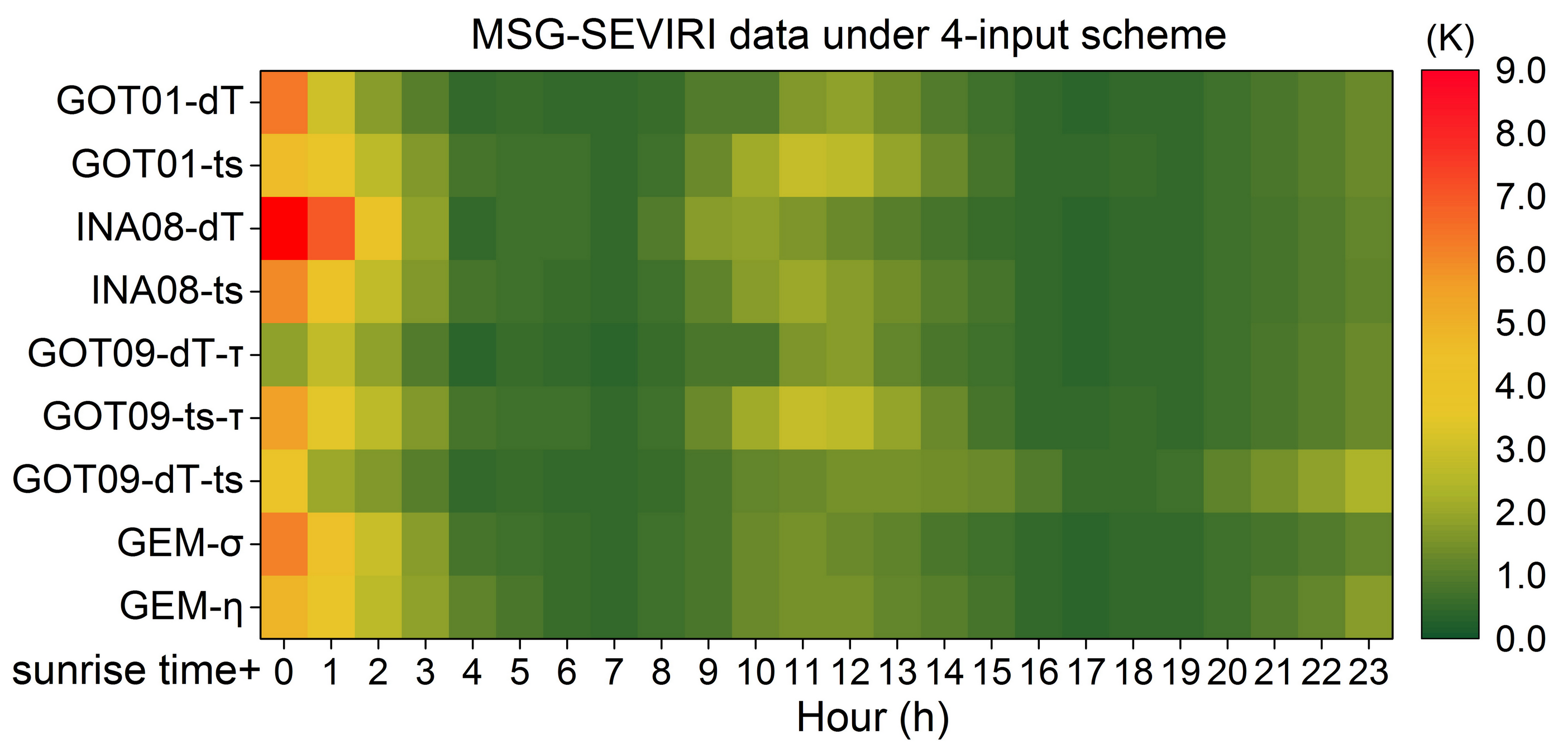
[5] Comprehensive assessment of diurnal land surface temperature cycle (DTC) models under clear-sky condition
- Obtain nine representative four-parameter DTC models with a set of parameter-reduction strategies.
- Comprehensive assessment of DTC models with geostationary satellite data and in-situ measurements.
- Provide the parameter-reduction order and the best-performance four-parameter DTC model.
- The examples of the DTC models are available at: DTC GitHub.
- Related publication: Hong et al., 2008.
Hourly RMSEs of the selcted nine four-parameter DTC models